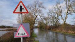
As of 16:00 GMT, the Environment Agency has 98 flood warnings and 175 flood alerts in place in England, with saturated ground and already-swollen rivers making flooding more likely.
Heavy rain in south-west England and south Wales has also prompted a Met Office yellow warning, which will remain in place until the end of the day.
The forecaster has warned that downpours are set to continue, with further weather warnings likely to come into force.
Met Office rain warnings have also been issued for Tuesday and Wednesday in parts of eastern Scotland.
There are currently two flood warnings and four alerts in Scotland and five flood alerts in Wales.
A flood warning means flooding is expected, and an alert means flooding is possible.
"There will be some heavy rain and the rain is falling on saturated ground so further flooding is possible, particularly as we move into the evening," Met Office meteorologist Tom Morgan said on Monday.
He added there was potential for "surface water on the roads", which could cause travel disruption.
And the weather is "set to remain unsettled throughout the remainder of the week", Met Office operational meteorologist Simon Partridge said.
He added there is expected to be "further spells of wet and windy weather for many areas of the UK", and "currently no sign of any prolonged dry weather for the next seven to 10 days".
The Met Office previously confirmed that rain fell every day of 2026 in south-west England and south Wales, with both areas seeing 50% more rainfall than usual.
The Environment Agency estimated at least 300 properties had been reported as flooded on Sunday, with about 16,200 more now having been protected.
"We urge people not to drive through flood-water - it is often deeper than it looks and just 30cm of flowing water is enough to float your car," Sarah Cook, the agency's flood duty manager cautioned.
Monday to Wednesday will be cloudy with intermittent rain for most areas. The heaviest downpours once again will be focused around south-west England and south Wales where rain will fall on very saturated ground.
From midweek onwards, a trend to colder and drier conditions is expected.
Snow showers are likely over hills and mountains in Scotland and perhaps northern England for a time but most parts of the UK should see a return to drier weather and sunshine throughout Thursday and into Friday.
Flood warnings are clustered in Devon and Hampshire, as well as between Gloucester and Worcester.
However flood alerts are scattered across much of England, apart from the far north and East Anglia.
Warwickshire Fire and Rescue Service warned that flooding was "imminent" after "heavy prolonged rainfall" had caused local levels at the River Dene to rise.
Floods Minister Emma Hardy said her thoughts were with those affected as she urged residents to follow local advice over the coming days.
Northern Ireland has had its wettest January in 149 years, while County Down and Cornwall had the wettest January on record, according to the Met Office.
February has also seen similarly intense rainfall.
Provisional Met Office data shows some parts of the UK recorded more rainfall in the first five days of the month than it would normally expect over the course of the whole month.
Aberdeenshire has been one of the wettest places of all, with Aboyne receiving more than 130% of its normal February rainfall in just five days.
Last month, Storm Chandra brought flooding and travel disruption, and saw dozens of schools close.
It was the third named storm to batter the UK so far this year, after Ingrid and Goretti.
Comments
No comments yet.
Log in to leave a comment.